Flooding in Chiangrai Province caused by Typhoon YAGI during September 2024
จังหวัดเชียงรายประสบอุทกภัยหลายครั้งในปี 2567 โดยเฉพาะ อ.แม่สาย ที่โดยปกติมักเกิดอุทกภัยประมาณ 2-3 ครั้งต่อปี แต่ในปีนี้มีเหตุการณ์น้ำท่วมเกิดขึ้นแล้วถึง 7 ครั้ง รวมถึงเหตุการณ์ในช่วงกลางเดือน
กันยายนครั้งนี้ด้วย สาเหตุสำคัญเกิดจากฝนที่ตกหนักต่อเนื่องหลายวันทั้งในพื้นที่จังหวัดเชียงรายเองและพื้นที่ต้นน้ำบริเวณประเทศเมียนมา ที่ได้รับอิทธิพลจากพายุไต้ฝุ่น “ยางิ” ส่งผลให้มีมวลน้ำปริมาณ
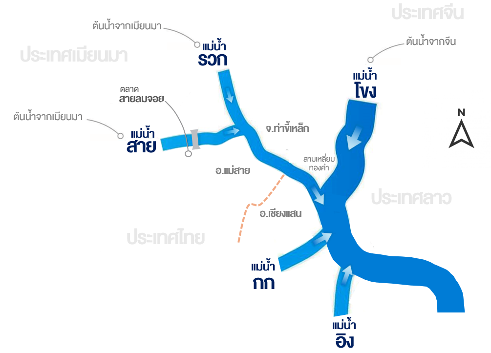
มหาศาล พร้อมด้วยเศษซากต้นไม้ กิ่งไม้ สิ่งปฏิกูล และดินโคลน ไหลจากต้นแม่น้ำรวกและแม่น้ำสาย ลงสู่พื้นที่ อ.แม่สาย อย่างรวดเร็วและรุนแรง
Chiang Rai Province experienced multiple flood events in 2024, especially in Mae Sai District, which typically encounters 2-3 flood events annually. However, this year the district has already experienced 7
flood events, including this one in mid-September. The primary cause was persistent heavy rainfall over several days in both Chiang Rai Province and the headwaters in Myanmar, influenced by Typhoon
"YAGI". This led to massive water volume, along with tree trunks, branches, waste, and mud, rapidly and violently flowing from the headwaters of the Ruak River and Sai River into Mae Sai District.


กรมป้องกันและบรรเทาสาธารณภัยรายงานเมื่อวันที่ 13 กันยายน 2567 เวลา 18.00 น. ระบุว่าได้เกิดน้ำท่วม น้ำป่าไหลหลาก และดินถล่มในพื้นที่ 6 อำเภอ 24 ตำบล 123 หมู่บ้านของจังหวัดเชียงราย ประกอบด้วย
1) อ.แม่สาย บริเวณ ต.เวียงพางคำ ต.แม่สาย ต.เกาะช้าง ต.ศรีเมืองชุม
2) อ.เชียงของ บริเวณ ต.เวียง
3) อ.เมืองเชียงราย บริเวณ ทน.เชียงราย ต.รอบเวียง ต.ดอยฮาง ต.แม่ยาว ต.ริมกก ต.ห้วยชมภู ต.บ้านดู่ ต.แม่ข้าวต้ม ต.นางแล
4) อ.แม่จัน บริเวณ ต.แม่คำ ต.ศรีค้ำ ต.จันจว้า ต.จันจว้าใต้ ต.จอมสวรรค์
5) อ.แม่ฟ้าหลวง บริเวณ ต.เทอดไทย ต.แม่สลองนอก ต.แม่สลองใน ต.แม่ฟ้าหลวง
6) อ.เชียงแสน บริเวณ ต.เวียง
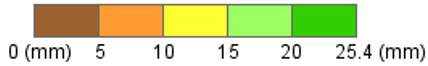
มีบ้านเรือนได้รับผลกระทบ 45,329 ครัวเรือน มีผู้เสียชีวิต 4 ราย และมีผู้ได้รับบาดเจ็บ 2 ราย จากเหตุดินถล่มที่ อ.แม่ฟ้าหลวง ซึ่งจากการวิเคราะห์ภาพถ่ายดาวเทียมพบว่า ตลอดเดือนกันยายนจังหวัดเชียงรายมีพื้นที่ถูกน้ำท่วมประมาณ 247,512 ไร่ โดยที่ อ.แม่สาย มีพื้นที่น้ำท่วม 31,859 ไร่
The Department of Disaster Prevention and Mitigation reported on 13 September 2024 at 6:00 p.m. that flooding, flash floods, and landslides occurred in 6 districts, 24 sub-districts, 123 villages of Chiang Rai Province, comprising:
1) Mae Sai District: Wiang Phang Kham Sub-district, Mae Sai Sub-district, Ko Chang Sub-district, and Si Mueang Chum Sub-district
2) Chiang Khong District: Wiang Sub-district
3) Mueang Chiang Rai District: Chiang Rai Municipality, Rop Wiang Sub-district, Doi Hang Sub-district, Mae Yao Sub-district, Rim Kok Sub-district, Huai Chomphu Sub-district, Ban Du Sub-district, Mae Khao Tom Sub-district, Nang Lae Sub-district.
4) Mae Chan District: Mae Kham Sub-district, Si Kham Sub-district, Chan Chwa Sub-district, Chan Chwa Tai Sub-district, Chom Sawan Sub-district
5) Mae Fa Luang District: Thoet Thai Sub-district, Mae Salong Nok Sub-district, Mae Salong Nai Sub-district, Mae Fa Luang Sub-district
6) Chiang Saen District: Wiang Sub-district.
A total of 45,329 households were affected with 4 fatalities and 2 injuries caused by landslides in Mae Fa Luang District. An analysis from satellite imagery revealed that Chiang Rai Province had 247,512 rai of flood areas in September with Mae Sai District accounting for 31,859 rai.

(Facts and Causes of the Flooding)
(Weather Conditions and Rainfall)
พายุไต้ฝุ่น “ยางิ” เคลื่อนขึ้นฝั่งบริเวณประเทศเวียดนามในวันที่ 7 กันยายน 2567 จากนั้นได้อ่อนกำลังลงเป็นพายุโซนร้อนบริเวณเมืองนิญบิ่ญในวันที่ 8 กันยายน 2567 และอ่อนกำลังต่อเนื่องเป็นพายุดีเปรสชันและหย่อมความกดอากาศต่ำกำลังแรงปกคลุมบริเวณประเทศเวียดนาม
ตอนบนในวันเดียวกัน แต่อิทธิพลของพายุไต้ฝุ่น “ยางิ” ส่งผลทำให้เกิดฝนตกหนักบริเวณประเทศลาวตั้งแต่วันที่ 6 กันยายน 2567 หลังจากนั้นได้แผ่วงกว้างมาถึงจังหวัดน่าน พะเยา เชียงราย และประเทศเมียนมา โดยเฉพาะช่วงวันที่ 9-10 กันยายน 2567 ที่มีฝนตกหนักมากบริเวณ
ประเทศเมียนมา รวมถึงเชียงราย เชียงใหม่ และแม่ฮ่องสอน ซึ่งฝนที่ตกหนักในเมียนมาทำให้มีมวลน้ำจำนวนมากไหลลงสู่แม่น้ำรวกและแม่น้ำสาย ซึ่งเป็นสาเหตุทำให้น้ำท่วมหนัก โดยเฉพาะในพื้นที่ปลายน้ำช่วงอำเภอแม่สายของประเทศไทย และจังหวัดท่าขี้เหล็กของประเทศเมียนมาที่ได้รับผลกระทบอย่างหนัก
Typhoon “YAGI” made landfall in Vietnam on 7 September 2024. After that, it weakened into a tropical storm near Ninh Binh on 8 September 2024 and further weakened into a depression and strong low-pressure cell covering northern Vietnam on the same day. However, the influence of Typhoon
“YAGI” caused heavy rain in Laos since 6 September 2024. The impact then spread to Nan, Phayao, Chiang Rai provinces, and Myanmar, especially during 9-10 September 2024, when extremely heavy rain occurred in Myanmar, Chiang Rai, Chiang Mai, and Mae Hong Son provinces. The heavy rain in Myanmar
resulted in a large volume of water flowing into the Ruak and Sai rivers, causing severe flooding, particularly in the downstream areas of Mae Sai District of Thailand and Tachileik Province of Myanmar, which were severely affected.

(Rainfall maps that analysis from satellite imageries of GSMaP during 6-11 September 2024)

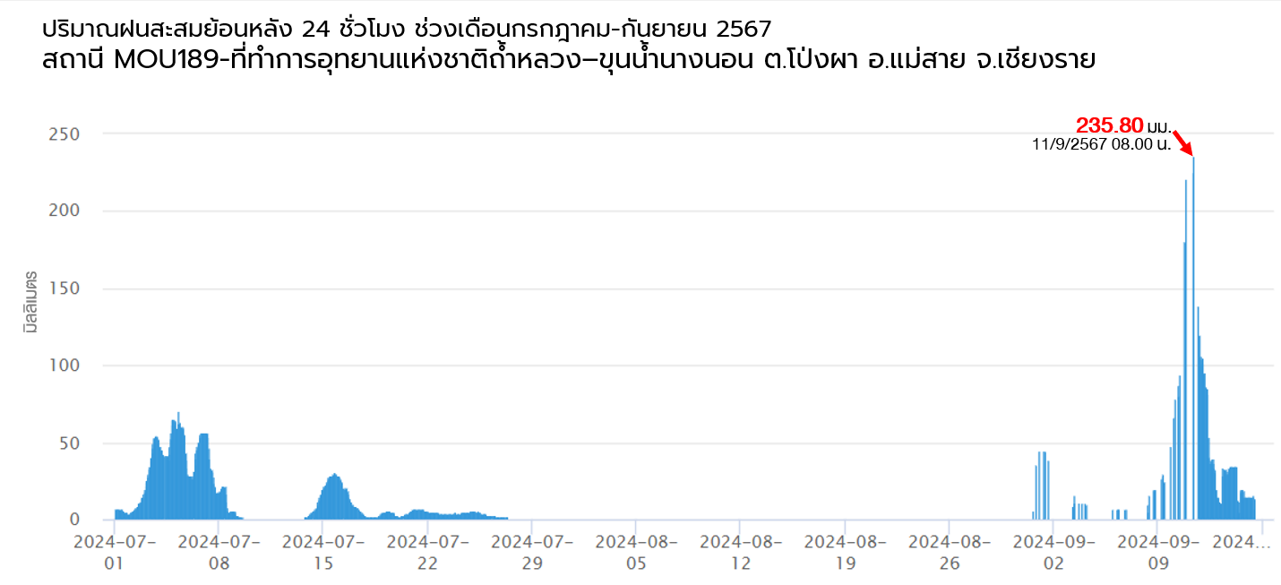
ถึงแม้พายุ “ยางิ” ได้สลายตัวไปแล้วตั้งแต่วันที่ 8 กันยายน 2567 แต่เนื่องจากได้เกิดร่องมรสุมพาดผ่านบริเวณภาคเหนือและภาคตะวันออกเฉียงเหนืออย่างต่อเนื่องไปจนถึงช่วงกลางเดือน ส่งผลทำให้บริเวณภาคเหนือยังคงมีฝนตกหนักต่อเนื่องออกไป
อีกแม้พายุสลายตัวไปแล้ว โดยเฉพาะอย่างยิ่งในวันที่ 11 กันยายน 2567 สถานีโทรมาตรตรวจวัดปริมาณน้ำฝน ณ ที่ทำการอุทยานแห่งชาติถ้ำหลวง-ขุนน้ำนางนอน อ.แม่สาย จ.เชียงราย สามารถตรวจวัดปริมาณฝนสะสม 24 ชั่วโมงย้อนหลัง
สูงสุดได้ถึง 235.8 มิลลิเมตร ซึ่งถือเป็นปริมาณฝนที่สูงมากเมื่อเทียบกับเกณฑ์มาตรฐานของกรมอุตุนิยมวิทยา (ฝนตกหนักมาก หมายถึง ใน 1 วัน มีฝนตกมากกว่า 90 มิลลิเมตร ขึ้นไป)
Although Typhoon “YAGI” dissipated on 8 September 2024, the monsoon trough later lay across the North and the Northeast until mid-September. This resulted in persistent heavy rain in the North, even after the storm dissipated. Particularly, on 11
September 2024, the rainfall telemetry station at Tham Luang- Khun Nam Nang Non National Park Office in Mae Sai District, Chiang Rai Province recorded the highest 24-hour cumulative rainfall of 235.8 millimeters, which was considered
extremely high when compared with the Thai Meteorological Department's standard criteria (very heavy rainfall is defined as exceeding 90 millimeters of rain per day).
Weather maps of monsoon trough continuously lay across the North and the Northeast during 10-18 September 2024

at Tham Luang- Khun Nam Nang Non National Park Office, Pong Pha Sub-district, Mae Sai District, Chiang Rai Province
น้ำท่วมเชียงรายในครั้งนี้ไม่ได้มีสาเหตุเพียงปริมาณฝนที่ตกในช่วงต้นเดือนถึงกลางเดือนกันยายน 2567 เท่านั้น หากแต่เป็นผลสืบเนื่องจากฝนตกสะสมที่เกิดขึ้นอย่างต่อเนื่องมาตั้งแต่เดือนมิถุนายน 2567 ทั้ง
บริเวณต้นแม่น้ำสายในประเทศเมียนมาและพื้นที่ปลายแม่น้ำสายบริเวณจังหวัดเชียงราย โดยเฉพาะอย่างยิ่งในช่วงครึ่งหลังของเดือนสิงหาคมจนถึงครึ่งเดือนแรกของเดือนกันยายน ทำให้พื้นดินในบริเวณ
ดังกล่าวมีความชุ่มชื้นสูงและมีศักยภาพในการอุ้มน้ำลดต่ำลง ดังนั้น เมื่อมีฝนตกเพิ่มเติมในช่วงต้นถึงกลางเดือนกันยายน น้ำจึงไม่สามารถซึมลงสู่ดินได้อีก ส่งผลให้เกิดปริมาณน้ำหลากบนผิวดินในปริมาณมาก
The flooding in Chiang Rai Province was not only caused by the rainfall that occurred from early to mid-September 2024 but also resulted from cumulative rainfall that had occurred continuously since June 2024, both in the upstream areas of
the Sai River in Myanmar and the downstream areas of the Sai River in Chiang Rai Province. This was particularly significant during the second half of August until the first half of September. As a result, the soil in these areas became highly
saturated with reduced water absorption capacity. Therefore, when additional rainfall occurred during early to mid-September, the water could no longer be absorbed into the ground, resulting in extensive surface runoff.
Maps of volume and distribution of rainfall during June and September 2024

Maps of weekly surface soilmoisture

(Area Characteristics and Water Infrastructure)
แม่น้ำสายมีต้นน้ำอยู่ในประเทศเมียนมา โดย 80% ของลำน้ำอยู่ในประเทศเมียนมา ส่วนที่เหลืออีก 20% อยู่ในพื้นที่ อ.แม่สาย ของประเทศไทย และจังหวัดท่าขี้เหล็กของประเทศเมียนมา ในปัจจุบันพื้นที่ต้นน้ำได้ถูกเปลี่ยนจากพื้นที่ป่าให้กลายเป็นพื้นที่เกษตรกรรมและเหมืองแร่ ทำให้ความสามารถในการชะลอน้ำของพื้นที่ลดต่ำลง
มาก อีกทั้งลักษณะภูมิประเทศบริเวณแม่สาย-ท่าขี้เหล็กเป็นที่ราบระหว่างหุบเขา ทำให้น้ำที่หลากลงมาจากต้นน้ำมีความเชี่ยวและแรงโดยธรรมชาติ ซึ่งเป็นสาเหตุทำให้มวลน้ำพร้อมเศษซากต้นไม้ กิ่งไม้ สิ่งปฏิกูล พร้อมดินโคลน ไหลลงมาสู่ อ.แม่สาย อย่างรวดเร็วและรุนแรง ทั้งนี้ จากภาพถ่ายจากดาวเทียมที่บันทึกไว้เมื่อวันที่ 13 กันยายน
2567 บริเวณใกล้ชายแดนประเทศเมียนมา ในเขตอำเภอแม่สาย พบรอยการเกิดดินถล่มบนภูเขาเป็นทางยาวหลายจุด (บริเวณสีน้ำตาลเข้ม) โดยแต่ละรอยมีความกว้างประมาณ 20–30 เมตร และมีความยาวตั้งแต่หลายสิบเมตรจนถึงหลายร้อยเมตร ซึ่งเป็นหนึ่งในสาเหตุที่ทำให้เกิดการทับถมของดินโคลนจำนวนมากในพื้นที่ด้านล่าง
The Sai River originates in Myanmar, with 80% of its stream located in Myanmar and the remaining 20% situated in Mae Sai District of Thailand and Tachileik Province of Myanmar. Currently, the headwater areas have been converted from forestlands to agricultural areas and mining sites, significantly reducing the area’s water retardation capacity.
In addition, the topography of the Mae Sai-Tachileik area consists of plains between valleys, naturally causing rapid and forceful water flows from the headwater areas. This resulted in swift and violent water flows carrying tree debris, branches, waste, and mud into Mae Sai District. According to satellite imagery captured on 13 September 2024
near the Myanmar border in Mae Sai District, multiple long landslide tracks were observed on the mountains (shown in dark brown areas). Each track was approximately 20-30 meters wide and ranged from tens to hundreds of meters long. This was one of the factors that contributed to substantial mud accumulation in the lower areas.
Topography of the Mae Sai-Tachileik area

Landslide track on the mountainside in Mae Sai District

การระบายน้ำจากแม่น้ำสายและแม่น้ำรวกลงสู่แม่น้ำโขงมีปัญหาดังนี้ ดังนี้
1) ระดับน้ำในแม่น้ำโขงที่สูงขึ้น บริเวณสบรวกหรือจุดบรรจบระหว่างท้ายน้ำของแม่น้ำ
รวกและแม่น้ำโขงที่อำเภอเชียงแสนมีระดับน้ำเพิ่มสูงขึ้นมาก เนื่องจากระดับน้ำในแม่น้ำโขงที่เพิ่มขึ้นอย่างต่อเนื่องตั้งแต่ช่วงปลายเดือนกรกฎาคม โดยเฉพาะในช่วงเดือน
สิงหาคมและกันยายน ส่งผลให้ศักยภาพการระบายน้ำผ่านแม่น้ำสายและแม่น้ำรวกค่อนข้างต่ำ
There are significant problems in draining water from the Sai River and Ruak River into the Mekong River:
1) Rise in Mekong River’s Water Levels.
At Sop Ruak Confluence or the meeting point of the downstream
downstream end of the Ruak River and Mekong River in Chiang Saen District, the water levels rose significantly due to the continuous increase in the Mekong River’s water levels since the end of July, particularly during August and September. This caused a relatively
low water drainage capacity through the Sai and Ruak rivers.
(Water level of Mekong River at Chiang Saen District, Chiangrai Province during June to October 2024)

2) การขยายตัวของพื้นที่เมืองทั้งในฝั่งแม่สายและท่าขี้เหล็ก
ช่วง 10-15 ปีที่ผ่านมา อำเภอแม่สายของประเทศไทยและจังหวัดท่าขี้เหล็กของประเทศเมียนมาต่างขยายตัวเป็นเมืองขนาดใหญ่อย่างต่อเนื่อง ทำให้ทางน้ำเปลี่ยนแปลงไป และหลายจุดที่เคยเป็นพื้นที่
สำหรับระบายน้ำได้ถูกเปลี่ยนให้เป็นพื้นที่อยู่อาศัย ในอดีตแม่น้ำสายเคยมีความกว้าง 130-150 เมตร แต่ปัจจุบันถูกรุกล้ำลำน้ำจากสิ่งปลูกสร้างจนเหลือความกว้างเพียง 20-50 เมตรเท่านั้นในช่วงพื้นที่เมือง และบางจุดแคบลงเหลือเพียง 7 เมตร สามารถเดินข้ามได้ ซึ่งปัญหาที่เกิดขึ้นเป็นอุปสรรค
อย่างมากต่อการระบายน้ำลงสู่แม่น้ำโขง ซึ่งไม่ต่างจากแม่น้ำกกที่แต่เดิมรอบ ๆ ลำน้ำเป็นเรือกสวนไร่นาและเป็นพื้นที่รองรับน้ำ แต่ถูกปรับเปลี่ยนเป็นสถานที่พักผ่อน โรงแรม ศูนย์ราชการ และอื่น ๆ ส่งผลให้ลำน้ำแคบลงมาก
2) Urban Expansion in Mae Sai and Tachileik.
Over the past 10-15 years, both Mae Sai District in Thailand and Tachileik Province in Myanmar have been continuously expanding into large urban areas. This urbanization has altered natural waterways and many areas previously used for water
drainage have been turned into residential areas. In the past, the Sai River was 130-150 meters wide, but currently, urban constructions have encroached on its bank, reducing its width to just only 20-50 meters in urban areas, with some points narrowing to as little as 7 meters – narrow enough to walk across. These
changes are significant obstacles to water drainage into the Mekong River. Similarly, the Kok River, once surrounded by farmland and water retention areas, has been transformed into recreational areas, hotels, government centers, and other facilities, causing the river to become much narrower.
Comparision of area characteristic of Mae Sai District and Tachileik Province in 2004 and 2024


(Water Management and Operational Limitations)
3.1 ความท้าทายในการบริหารจัดการน้ำข้ามพรมแดน การบริหารจัดการแม่น้ำสายและแม่น้ำรวกของประเทศไทยต้องอาศัยความร่วมมือจากประเทศเมียนมาและประเทศจีน ซึ่งเป็นประเด็นที่มีความซับซ้อนและต้องใช้กระบวนการที่อาจต้องใช้ระยะเวลานาน
3.2 ข้อจำกัดด้านระบบเตือนภัยและการคาดการณ์ การขาดระบบเตือนภัยล่วงหน้าที่ช่วยให้สามารถเตรียมรับมือได้ทันเวลา รวมทั้งการไม่สามารถประเมินปริมาณน้ำที่จะ
ไหลลงมายังบริเวณ อ.แม่สาย ได้ เนื่องจากไม่มีสถานีตรวจวัดปริมาณน้ำฝนบริเวณต้นน้ำซึ่งอยู่ในประเทศเมียนมา
3.3 ข้อจำกัดในการขุดลอกและขยายลำน้ำ บางส่วนของแม่น้ำรวกและแม่น้ำสายเป็นแนวพรมแดนระหว่างประเทศไทยและเมียนมา การดำเนินการขุดลอกหรือขยายลำน้ำจึงมีความอ่อนไหวในประเด็นด้านความมั่นคงของประเทศ ซึ่งต้องได้รับความเห็นชอบจากทั้งสองประเทศ
3.4 การบริหารจัดการระดับน้ำในแม่น้ำโขงร่วมกับจีน ปัจจุบันยังไม่มีความร่วมมือที่เป็นรูปธรรมกับประเทศจีนในการจัดการระดับน้ำในแม่น้ำโขง ที่จะต้องขอความร่วมมือจากประเทศจีน
3.1 Challenges in Transboundary Water Management. Water management of the Sai River and Ruak River in Thailand requires cooperation from Myanmar and China, which is a complex issue that may require a lengthy process.
3.2 Limitations of Warning Systems and Forecasting. There is a lack of an early warning system that helps prepare for floods timely and an
inability to assess the
amount of water flowing into Mae Sai District due to the absence of rain gauge stations at the headwaters in Myanmar.
3.3 Limitations in dredging and expanding the river. Some parts of the Ruak and Sai rivers are the border between Thailand and Myanmar. Dredging or expanding the river channel is sensitive to national
security issues and requires approval from both countries.
3.4 Water Level Management in the Mekong River with China. Currently, there is no concrete cooperation with China in water level management in the Mekong River, which requires collaboration from China.